

Laurel-Snow State Natural Area | Rhea County, Tennessee
Looking for an inviting hike with waterfalls, history, and breathtaking gorge views? The Laurel Falls Trail in Rhea County delivers all three.
Plan Ahead
- Gates Open: 8:00 AM
- Gates Close: 7:00 PM (locked daily)
Be sure to allow plenty of time to complete your hike and exit before closing.

Laurel Falls – 80 Feet of Scenic Power
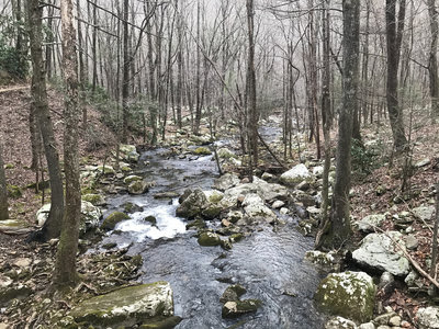
The hike follows Richland Creek upstream, beginning on a wide, flat path along an old coal mining road. After about one mile, the trail narrows and climbs gradually toward the old Dayton Reservoir site.
At roughly 1.5 miles in, the trail forks:
- Right → Laurel Falls
- Left → Snow Falls & Buzzard Point
The final stretch to Laurel Falls is steep, featuring switchbacks and even a short rock pass-through — but the reward is worth it. The falls plunge approximately 80 feet, followed by dramatic cascading drops totaling several hundred feet.
Snow Falls & Overlooks
If you head left at the fork:
- Snow Falls (approx. 35 feet)
- Buzzard Point & Bryan Overlook (Raven Point)
- Gorge views carved by Morgan, Henderson, Laurel, and Richland Creeks
The full round trip to Snow Falls and overlooks is approximately 8 miles and may require crossing Richland Creek.
What Makes This Area Special?
- 2,259 acres on Walden Ridge of the Cumberland Plateau
- Historic coal mining remnants
- Old Dayton Reservoir dam remains
- Virgin timber stands
- Diverse plant life
- First National Recreation Trail designated in Tennessee
This natural area contains a segment of the Cumberland Trail — Tennessee’s only linear state park — which will eventually stretch 300 miles across 11 counties from Cumberland Gap to Signal Point near Chattanooga.
Trail Details
- 10.5 miles of hiking trails
- White metal trail markers (Laurel segment)
- Painted white rectangles on trees (Snow Falls segment)
- Dogs allowed (on leash)
- Fishing permitted
- Designated camping only (registration required at friendsofthecumberlandtrail.org)
- No hunting
Directions
From US 27 north of Dayton:
- Turn onto Walnut Grove Road
- Go ¾ mile → Left on Back Valley Road
- Go 0.7 mile → Right onto unmarked gravel road (Richland Creek Road)
- Follow 1 mile to trailhead parking
(Look for the small white church at the turn.)
Bonus Stop
Just outside the natural area you’ll find Gooch Creek Arch, another hidden gem worth exploring.
Whether you’re chasing waterfalls, exploring mining history, or just enjoying a peaceful creekside hike — Laurel-Snow offers one of the most scenic outdoor experiences in Rhea County.

Comments are closed